


Announcement!
After 16 years (1996-2012) of being Business Partners McTigue and Spiewak are taking their business ventures in separate directions. Both land surveyours are still offering their surveying services and can be reach at the links below.
If you would like to reach McTigue & Associates, Ltd. please click on the following link to his new web-site: www.landsurveyorschicago.com
If you would like to reach Andrew Spiewak Land Surveyor, Inc. please click on the following link to his new web-site: www.landsurveyors.pro


Land Surveying Frequently Asked Questions
To help you to understand the steps to follow in land surveying or civil engineering projects, find the answers to a few commonly asked questions.
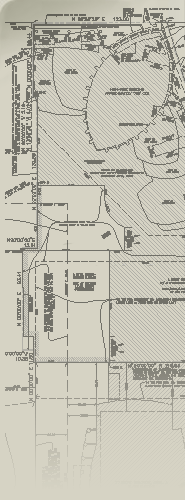
Land Surveying
Providing an indispensable service to attorneys, builders and land developers, as well as homeowners throughout the Chicagoland six-county area, and southeastern Wisconsin, McTigue & Spiewak, Inc. is available for all types of land surveying work The professionals provide expertise in land surveys of all types.Land Surveying Services
For professional or homeowner, we prepare mortgage surveys or ALTA/ACSM Land Title Surveys for real estate closings, refinancing or building permits, as well as Plats of Subdivision / Resubdivision, Plats of Easement or Plats of Vacation. Attorneys, contractors or land developers will appreciate our service in:- ALTA/ACSM Land Title Surveys
- Plats of Subdivision
- Topographic Surveys (Existing Conditions for Design)
- Topographic Surveys (Final Grading for Permit)
- As-Built Surveys
- Boundary Surveys / Mortgage Surveys / Plats of Survey (for Permit or Closing)
- Tax Division Maps / Plats of Annexation
- Plats of Easement / Plats of Vacation
- Preparation of Legal Descriptions
- Title & Deed Research
Condominium Surveying
We specialize in new construction condominium surveys or condominium conversion of existing buildings, delineating the limits of ownership, both horizontal and vertical, for each unit, and those areas of shared ownership within the condominium association.- Condominium Conversion
- Condominium Surveys
- High-Rise Surveys
Construction SURVEYING
- Building / Foundation Lay-Out and Staking
- Foundation Location / Spot Foundation
- Lay-Out of Proposed Improvements (Utilities, Driveways, Grades, Curbs, etc.)
- Construction Staking
Special Purpose Land Surveying Services
- Preparation of Permit Applications
- Elevation Certificate
- Establish Vertical and Horizontal Controls (Damage Control Monitoring, Elevation Certificate)
- Zoning Assistance
- Communication Tower